Exhibition “Cities of the world. Views and maps”
Exposición «Ciudades del mundo. Vistas. Planos»
Do you want to know how cities have been represented throughout history? We offer you a guided tour through the exhibition “Cities of the world. Views and maps”
¿Quieres conocer cómo se han ido representando las ciudades a lo largo de la historia? Te ofrecemos una visita guiada por la exposición «Ciudades del mundo. Vistas. Planos».
The event will be “Live” in presence (if it will be allowed by the covid rules, otherwise it will not be held).
El evento será presencial (siempre que sea posible por la normativa covid, en caso contrario, tendría que anularse).
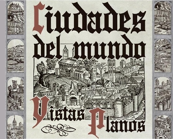
We offer a guided tour of the exhibition entitled “Cities of the world. Views and maps”. This exhibition brings together a careful selection of views and maps of cities of the world, with the purpose that Georg Braun summarized in the prologue of his monumental Civitates Orbis Terrarum: “What would be more pleasant than, in the safety of home, without fear of danger, to be able to contemplate in these books the shape of the whole earth we inhabit, adorned with the splendor of its various regions, rivers, cities and fortresses?”
Visitors will be able to admire pieces such as the Liber Chronicarum, an incunabula book about universal history containing around ninety illustrations of cities of the world; original views taken from a great 16th century publishing project, the Civitates Orbis Terrarum, or the great map of Madrid by Pedro Texeira, republished in 1881 by the National Geographic Institute.
Se ofrece una visita guiada por la exposición titulada «Ciudades del mundo. Vistas. Planos». Esta exposición reúne una esmerada selección de vistas y planos de ciudades del mundo, con el propósito que Georg Braun resumía en el prólogo de su monumental Civitates Orbis Terrarum: «¿Qué sería más agradable que, en la seguridad del hogar, sin miedo a los peligros, poder contemplar en estos libros la forma de toda la tierra en que habitamos, adornada con el esplendor de sus diversas regiones, ríos, ciudades y fortalezas?».
Se podrán admirar piezas como el Liber Chronicarum, un libro incunable sobre historia universal que contiene alrededor de noventa ilustraciones de ciudades del mundo, también vistas originales extraídas de un gran proyecto editorial del siglo XVI el Civitates Orbis Terrarum, o el gran plano de Madrid de Pedro Texeira reeditado en 1881 por el Instituto Geográfico.
Objectives / Objetivos: The objective is to make known part of the cartographic collections that are kept in the National Geographic Institute and to spread the knowledge about old cartography among the citizens. / El objetivo es dar a conocer parte de los fondos cartográficos que se conservan en el Instituto Geográfico Nacional y difundir el conocimiento acerca de cartografía antigua entre los ciudadanos.
Event language / Idioma del evento: Spanish / Español
Country / País: Spain / España
Address/ Dirección: C/ General Ibáñez Ibero, 3. 28003 Madrid
Booking / Reservas: documentacionign@mitma.es
Reference person / Persona de contacto: Nuria Plaza Medina
Organiser / Organiza: National Geographic Institute of Spain / Instituto Geográfico Nacional de España
Expected duration / Duración estimada: Around 1 hour / Aproximadamente 1 hora
Event program / Programa del evento: 13 h April 1 abril Exhibition Catalogue / Catálogo de la exposición
ID.U.N.411